
And so a new era begins - I am now a Rwandan tourist and no longer a VSO volunteer. My exit interview completed and new visa issued, I was ready to start exploring parts of Rwanda I had previously only read about in the tourist guide.

On the 1st September, 4 of us took off in our hired vehicle, a Rav 4x4, heading for the southern part of Rwanda on the Congo border at the southern end of Lake Kivu, to make the first stop of our journey in Cyangugu where we would stay with another volunteer who lives and works there. On our way down there we passed the refugee camp where thousands of Congolese have fled from DRC.
Our route took us down through Nyungwe forest with the hope that we would be able to do one of the guided walks through the rainforest, (walking is forbidden in the forest without a guide) unfortunately we were unable to find something which fitted in with our time schedule but we did take the opportunity of stopping at Uwinka Visitor Centre where we learned about the Congo/Nile divide and then stopped at the very exclusive Nyungwe Lodge for coffee.


Our day spent in Cyangugu took us down the steep slopes and tracks to the shores of Lake Kivu where we spent a pleasant afternoon watching the locals swimming in the water and of course the odd refreshement stop, the most interesting of which was right on a tiny piece of land between Rwanda and the Congolese border beyond the giant flood barriers at the mouth of river where it flows into Lake Kivu. We took the opportunity of celebrating our one year anniversary, with 6 of us who had all arrived together, along with much reminiscing and reflecting about our respective times over the last 12 months.


The next morning we were all ready for an early departure to start the 227 km Nile/Congo route which was only opened in November 2011. The first part of our journey took us on a variation of tarmac road and road under construction but we were impressed at the general work which was going on to create this new road, however after the first 20 km we realized why this route has been designated for hiking or 4x4 vehicles only. The track??? snaked its way up hill and down dale at an alarming rate of knots with more hair pin bends than I cared to think about and most of the time we prayed that we would not encounter another vehicle going in the opposite direction, as many parts of the track were only wide enough for our own vehicle, particularly where the land had slipped and fallen away. However, Dave our fearless driver took the whole thing in his stride and never wavered from his task, as the knuckles in the back clutched ever tighter and the conversation of the passengers varied from very fast and high pitched to absolute silence.
The views were spectacular and there were many requests for photo stops - aka bush “wee” stops and it was with great relief that we reached our first destination at Kibuye some 5 hours later where we were able to relax at the spectacular Home Saint Jean Hostel over a well earned beer.
The second leg of the journey to Gisenye at the top end of the lake was marginally shorter but even scarier when we, at one point, ran out of track and found a whole crew of people hacking soil out of the hillside. We then entered into some lively discussion with the locals as to whether we continue our attempt to descend or attempt to reverse back up the hillside. We are still unsure whether we took the wrong track, as the tourist map/leaflet we were following, was very confusing to say the least and bore no resemblance to the route we were on, however we manfully continued and found some more solid ground to follow further on. The map showed various tea and coffee plantations which it would have been nice to stop off at, but we never found any means of accessing them. Our second day of travelling took us to our favourite place of Paradis Malahide, just south of Gisenye, where we were greeted like long lost friends. We had completed our journey in only two days from the south to the north end of the lake and it was particularly impressive, knowing that in ten years times there will be a proper road all the way up the lakeside, which will be bustling with traffic.
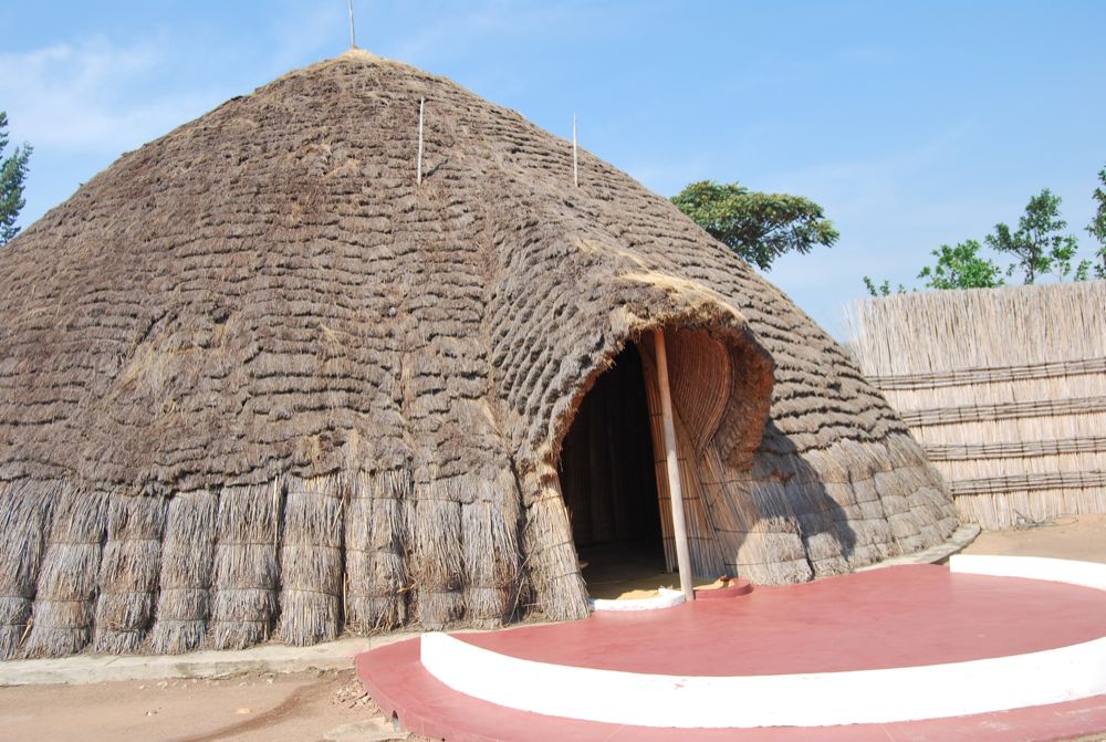
The final day of our exploration was inland down the Ngororera road, which is now a proper tarmac road all the way but with continual landslides, which had to be avoided and that’s before the rainy season really gets into full throttle. From there we headed to Nyanza, the historical site of the Rwandan kings to visit the thatch roofed palace now an Ancient History Museum.
“Based in Nyanza, 88 km south of Kigali Capital City, this was the residence of King Mutara III Rudahingwa and the Royal Palace that was traditionally built. This Palace offers a glimpse into Rwandan traditional seat of their monarchy, it is an impressive museum, restored to its 19th century state and made entirely with traditional materials. Recently the Long horned Traditional cows, Inyambo were also introduced for cows make up most of Rwandan Culture.”

| |
No comments:
Post a Comment